Monday, September 23, 2013

Hypertrax Rampage 2013 Jamboree, Dengkil, Sepang - 35.9Km

It all started when Alan sent me the link for Hypertrax Rampage in Dengkil. It was our first Jamboree ride. Why we said so because it is the first one we actually 'paid' for participation instead of gatecrash Penang Round Island ride.

Hypetrax Rampage is an XC track profile run through Paya Indah Wetlands and Palm Oil plantation. The track consist of 45M elevation with 80% dry and dusty track and 20% tarmac profile.

We arrived at Dengkil 1 hour before the event start. Our meeting point behind Dengkil's KFC with Alan and Hartz. Had our light breakfast at the mamak restaurant and lite chat before we unload our workhorse.

We met 2 new friends - Alan colleague who known as CK and CK's friend where he is known as The Doctor when we arrived at Medan Selera Dengkil. The event suppose to start at 8.30am but we were flagged off 15 minutes earlier. We were last batch to go after the flag off.

Warming up session and chit chatting before flag off.

First 8KM was tarmac ride, later are mostly trail. We went in to Payah Indah Wetlands after first 7Km riding on busy road. The trail from Paya Indah Wetlands to first Check Point was okay. Weather is hot but we still manage to get shades from the trees along the trail in wetlands. After the first check point KM16, we go through a long uncovered hot and dusty trail where the sun light hit our body directly.

I remembered passed by Alan where he offered help to a rider who got into flat and forgotten the pump. Due to the hot and humid weather, I can't wait but continue to ride looking for better shades trail.

After 10KM of hot and dusty trail, we came into tarmac road where there's newly developed village. Alan was nowhere to be seen except I bump into few riders where we used to ride in Putrajaya. When I approaching the main road, the marshal told me there's another 10KM to go and be prepare for uphill and a little more technical trail ahead. I reached the second check point where the marshal are giving out banana and mineral water to refuel. Riding in hot weather require lots of hydration and slow release carbohydrate.

Waste no time, I continue the ride myself, knowing Alan still behind and I have no idea where's Hartz, CK and Dr. The ride after second check point leads to palm oil plantation and some open space.

The challenge starts when I start to climb on the palm oil estate. I thought there's only one ascent, but I was wrong. The ride was like roller coaster. When I reached the top and happily cruising downhill, another hill in front of me make me feels like "Oh no! Not another one!". I manage to climb the first two and the last two I just push it up while grasping for air. Before I reach the last hill, I nearly fell into the trench, when I was passing through a trench where my front wheel are grinding at the edge of the wooden plank. Yet I still tell myself to look ahead instead of looking at the wooden plan. It was quite scary but I manage to get through it.

I was exhausted when I reach the last check point. The marshal cheer us up and keep on pushing us to go for the finishing line for the last 3KM. I bump into CK and Dr and found out that Dr lost control and crash during the third downhill. He dislocated his arm a little, but nothing serious still ridable.

I pass CK and Dr, pushing all my way to the last hill where everyone is exhausted and grasping for air. Once I reach on top of  the hill, it feels like the grand finale. I confidently cruise downhill even though the trail are quite rocky and try. Trusting my nevegal rubber, I just let my workhorse do the job while I just keep it steady.

After another 3KM, I reached the finishing line and my ranking was 289 out of 600 participant. Ride my way back to the starting line where all of us were awarded finisher medal.

Alan, CK and Dr arrived 15 minutes later after me. Hartz found me and he ranked at 288.

The ride finish around 11.30am, but lot's of riders waiting for lucky draw session and ranking where it dragged till 2.30pm.

Getting ready! Flag off in 5 mins!


Overall ride was good except for lack of water station and feed station. The trail are not clearly marked towards the end. Over 90% of the trail are ridable and XC based. Not much of technicalities and good for beginner.

True workhorse!


Create Maps or search from 80 million at MapMyRide

Sunday, September 08, 2013

Penang Round Island Ride 82KM

Initially, today ride suppose to be 46KM 56th Merdeka ride. Due to unforeseen mishap happened at the second Penang bridge, the organizer forced to postponed the date to 10th Nov 2013. Allan and me had prepared for this long time ago and we even took leave on Monday since we will not be able to drive back KL after long ride. We decided to do round island ride. We don't even notice that there's actually another round island event organized by CFAL (Campaign For A Line) Gclub cycle at the Esplanade.

The registration already closed by the time we found out this ride. We have no other alternative except for organizing it both on our own - two of us. CFAL event flagged off at 7AM. In order to avoid the masses and we knew that the entire route definitely going to be cramped with cyclist coming all over from the country and neighboring country, we plan to start this half and hour early.

This is my second round island ride since my first time during the days of scouting in Chung Ling High School Butterworth. The experience still stays fresh in my mind and it definitely will be there in our memory during the scout days. The bike we used during the scout days are those cheap steel mountain bike with lots of load to carry include tent and medical supplies. I still remember incident such as one of my friend crash into ravine when going downhill to Teluk Bahang from Balik Pulau, leg cramped half way at Batu Ferringhi and some of us split when half of them going directly home while another group of us stays back and make Ferringhi beach our overnight campsite. All the stupid and funny stuff we did during our scout day ride were just sweet memories.

Today, with all those lightweight cutting edge technology bike, it still takes your stamina and endurance to conquer this ride. We manage to finish it in 5 hour and 12 mins with all those heavy downpour, crosswind riding and battling uphill. I knew lots of them are better than any of us.

We started off around 6.30AM where Alan meet up with me at Penang Ferry bus stop. I started half and hour earlier from my house and take the ferry across. The weather was fine in the morning. The ferry was full of cyclist. Most of them with Red Bull CFAL jersey heading for the ride. Roadie and mountain biker all of them with the same goal - to conquer round island tour.


We (Alan and me!) started right after we gather at the jetty bus stop. Headed south to Bayan Lepas using Tan Sri Lim Chong Eu expressway. The sky is still dark, but there's a few cyclist riding along. We can see their flashy tail light from a far. We continuously cycle non stop till we reach the end track of Penang Airport - Bayan Lepas. We stopped a while for impromptu photo session. There we met another gang of cyclist also doing round island.

From far we can see dark cloud build up with strong cross wind. There's no place to hide or turning back. We brave ourself and continue our journey. We can feel the rain drops falling in front of us and the sky suddenly turned dark. Within a minutes, the downpour from drizzling turned into heavy downpour. All of us got soaked in the rain except for our back pack and bag.

We continuously ride even though the visibility suddenly reduced due to the down pour. Heavy cross wind keep on blowing us to the centre of the road. We struggling a while to keep our bike straight instead of zig zagging with the cross wind.

Couple of meters ahead, we sat Caltex petrol station. The first thing came into our mind was to stop there for shelter against heavy downpour. When we entered the station, we saw numerous cyclist seeking shelter there as well. While we were waiting for the downpour to recede, we saw group of roadie from CFAL ride passed by. The group was real fast even in the condition of heavy downpour.

Looking at the weather, we knew there's no way the downpour going to stop or recede any time soon. We continue our journey with some of the cyclist from CFAL. The road was well guided by the police and some volunteer even it is heavy downpour.

Our first climb was from Teluk Kumbar to Genting, Balik Pulau. The ascending was approximately 122M. The road is wet with rain. We stopped by to take banana for our first refuel before we continue the climb. The climb ended up on top of a corner overlook the west coast of the island with rainbow. The view was breathtaking, unfortunately we were just too tired to take the photo on that and continue our journey. The descending was relatively fast. The road condition was dry and I confidently descend faster. Top speed was around 45KM/h on MTB.

Continuing our journey in Balik Pulau, the road were flat all the way. The entire road like flooded with cyclist. We stopped by water station for rehydration and refuel with banana for the next long climb. After 10KM of flat profile ride, then came the climb from Balik Pulau to Teluk Bahang. First 4KM was good, then the next 3.5KM was moderate where I can only sustain my constant speed of 7 - 9KM/h. We climb to max elevation of 205M. On the way, we saw a few group stop by the road side stall for some durian and banana. Right after the climb, we get to enjoy our hard work - 6.82KM of smooth downhill with heavy downpour again. The road was winding and slippery. I try to be focused, moderately fast and steady. I have seen some roadie just gone way too fast and crash into another while going downhill. It took me 16 minutes with average speed of 25KM/h to descend 202M to Teluk Bahang.

From Teluk Bahang, we got another 20KM to go to reach the Esplanade, Georgetown. The road from Teluk Bahang to Georgetown was a narrow coastal road with mild ascend and descent. The ride was good, we zoom by Batu Ferringhi and Tanjong Tokong. Alan was nowhere been seen when I arrived Teluk Bahang, my thought was he might be in front of me. I continue my journey even though I was a little exhausted and lose focus. My knee and feet started to feel pain and numb.

It was drizzling all the way from Teluk Bahang till Tanjong Tokong. I keep on cycling until I reach Tanjong Tokong Petronas station. I knew I need fuel to continue this journey. I was exhausted seeking for Snicker chocolate at the station, nothing good except I found some Kickers bar and Milo chocolate. I just grab that to refuel myself. I was surprise to see Alan walked in to the same petrol station looking for something to refuel. He was quite behind me when he stopped by during the climb to take some scenic photo of Balik Pulau. After that he lost me as he knew I will continue the uphill battle to keep the momentum going. We chatted and rest for a while before we continue to our final leg to finish the round island loop.

Heading towards Esplanade from Tanjong Tokong was flat all the way. We passed by Gurney Drive where the traffic was quite heavy and towards E&O Hotel before reaching Esplanade. When we reached Esplanade, Alan suggest we go through the finishing line with RedBull inflatable arch and some Girl Guides delivering the water. We act like the participant and head direct into the finishing line, grabbed a bottle of water before we stopped and posed for photo.

We spent some time there lurking around at Esplanade. We continue our journey to CF food court at Swettenham Port for post ride refuel. I still left the last leg to go back home via the Ferry.

Overall, the ride was good. Good company and great experience cycling under heavy downpour, cross wind and battling uphill. We were exhausted, but the feels is totally great.

Some screenshot of overall track and elevation profile from my Garmin Etrex 30, (Please ignore the track at the water due to I leave my garmin on all the time):


Track and elevation from Google Earth:


The track I uploaded to MAPMYRIDE:


Create Maps or search from 80 million at MapMyRide

Sunday, March 10, 2013

Putrajaya Challenge Park

Two weeks after my last ride in Putrajaya Challenge Park, I manage to catchup with Joel and Alan for this morning ride. The ride was easy but due to lacking of exercising, our stamina and energy are all time low and exhausted.

The trail we took as easy one - Core Loop Trail. Lookout for the Green and Blue sign for Core and Easy loop.

I did some tracking on my Garmin GPSMAP62SC. 


Total length of Core Loop Trail + Moderate Downhill : 3.36Km
Ascent: 119M
Descent: 121M

Second gazebo rest area

Last bridge heading towards the viewpoint gazebo

Bike pose...

Breath taking view of Putrajaya from viewpoint gazebo.


Sunday, December 09, 2012

1301KM (Kuala Lumpur - Singapore - Kota Bahru)

How far can you go if you're given a 4WD. a GPS and with only 1 and half days time to do it?


I manage to clock 1301KM in 39 hours with a 4WD. This is the fastest route to Kota Bahru via Simpang Pulai - Gua Musang.

Why I choose this route instead of going up north via Karak Highway - Bentong - Raub - Kuala Lipis - Gua Musang way instead? Plain simple - from google map, when you search two destination (Here I search between Petaling Jaya and Kota Bahru), first preferred choice are:
1. Petaling Jaya - Bentong - Raub - Kuala Lipis - Gua Musang way, the other will be,
2. Petaling Jaya - Simpang Pulai - Gua Musang and the last one will be,
3. Petaling Jaya - Bukit Beruntung - Kuala Kubu Bahru - Fraser Hill - Raub - Gua Musang.

We did tested the first route from Petaling Jaya via Bentong - Raub - Kuala Lipis - Gua Musang way, we notice that even the route is short (469KM, 7 hours 42 mins), somehow the entire journey is slow, average speed is around 60km/h.

We tested the second route from Petaling Jaya via Simpang Pulai to Gua Musang (526KM, 7 hours 31 minutes). The journey from Petaling Jaya to Simpang Pulai is fast due to NSE where we can clock average speed of 100km/h and then from Simpang Pulai to Gua Musang via Cameron Highland bypass and Lojing (Average speed 50km/h due to crossing Titiwangsa Range). The entire journey is cut short nearly by 2 hours if you read the logged data from GPS.

Route 2 seems like 60km longer than route 1 but then the journey reduced by nearly 2 hours.

Be cautious when crossing Simpang Pulai -Lojing - Gua Musang Titiwangsa Range as the route is quite windy and lots of landslide occurs along the road. There's also lots of mist when you travel in the early morning. Look out for the logging truck that struck along the road.

 View from Gua Musang - Lojing Route - Palm Oil Estate

 View from Gua Musang - Lojing Route.

Panaromic View from Gua Musang - Lojing Route

Kuala Kerai - Gua Musang Route

Gua Musang - Kuala Kerai - Morning

Cameron Highland - Tanah Rata - Tapah Route (Low visibility downhill)

Cameron Highland - Tanah Rata - Tapah Route (Low visibility at dawn)


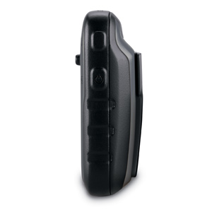
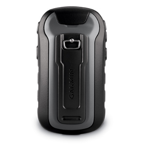
Garmin Etrex 30

I always wanted a handheld GPS for tracking and mapping purposes.
After a thorough survey from the web, I decided to land my hand on Garmin Etrex 30. It's the highest end of Garmin Etrex series. The new etrex using GPS and Russian GLONASS positioning system. Location log on is quite fast and accurate with both GPS and GLONASS turned on with WAAS.


The unit is quite small and fit nicely in my palm. Etrex is powered by two AA sized battery. A 2800 NiMH rechargeable battery will last you approximately 25 hours under normal operating condition.

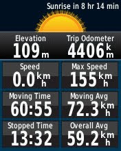
Here's a few screen capture from etrex 30. Manage to track approx 4.4K KM from the date I bought.
Elevation graph.
The route I drove from Kuala Lumpur to Kota Bahru, Kelantan via Simpang Pulai - Gua Musang scenic route.
Route I drove from Singapore to Kuala Lumpur via NSE.
One of the popular Thai Restaurant in Wakaf Bharu. Somewhere near Kota Bahru.

Comparison between Etrex 10, 20 and 30:

IMHO etrex 30 is small enough to mount in on mountain bike. It is also light enough to be pack behind your backpack when tracking. It can be link up to heart rate monitor, cadence sensor and temperature sensor.

There's a few list of original garmin accesories for etrex that worth checking out:
Bike mount - best for mountain biker. Comes with 4 cable ties.
I owned and used this on my MTB. Mounted it in the middle of the stem if it's long enough. Else I just mount in on one side of the handle bar.

Carrying case with belt clip - best to use when on trail. I used this on trail and notice that it's good for protection. The clip can be used to mount your etrex on your rucksack or belt.
The things that I don't like about the case is after a while the transparent screen will looks dirty and dull.

Another thing it's NOT ADVISABLE to install MATT screen protector on the etrex as it will make it harder to see after you put it into the carrying case.

Auto friction mount - best if you wanted to use it as track logger inside your vehicle. Fast deployment. Make sure you remove your etrex from the screen if it is not in used as expose under hot sun is not something the electronic love.

Premium heart rate monitor - best for trail runner and mountain biker. A must have tools if you wanted to track your fitness level with GPS location.

There are many more accesories for etrex. I found the above mentioned are basically good enough for everyday use include trail run and mountain biking.

Do share with me your experience with garmin etrex series.

Thanks


Wednesday, August 08, 2012

Bike Fitting

If you think every bike fit for anyone, than you're mislead. Proper bike fitting will enable you to full utilize and maximized the performance of your bike. Here's some article I scanned from MBUK Aug 2012 ISSUE on how do you fit your mountain bike! Hope this helps!


The scanned file size is approximately 2.4MB.

Monday, July 23, 2012

Tuesday, April 10, 2012

Bangkok International Motorshow 2012

IMG_0624.jpgIMG_0614.jpgIMG_0611.jpgIMG_0609.jpgIMG_0608.jpgIMG_0602.jpg
IMG_0592.jpgIMG_0590.jpgIMG_0577.jpgIMG_0572.jpgIMG_0571.jpgIMG_0563.jpg
IMG_0560.jpgIMG_0555.jpgIMG_0547.jpgIMG_0511.jpgIMG_0509.jpgIMG_0504.jpg
IMG_0479.jpgIMG_0478.jpgIMG_0465.jpgIMG_0460.jpgIMG_0456.jpgIMG_0453.jpg

33rd Bangkok International Motorshow 2012 held in Impact Arena, Don Muang, Bangkok.

This is my third visit to Bangkok International motorshow. The motorshow showcase latest automobile technologies. Don't forget the pretty showgirl from the motorshow as well.

I have a few friend asking me why go all the way to Bangkok for motorshow instead of you can get to visit KL Motorshow back here. Sad to say that in my humble opinion, Malaysian are doing things backward. That's how it happened not only to motorshow but other event as well. Those who attended Bangkok motorshow yearly will see the difference clearly from what we had in KL Motorshow.

Enjoy the photo and feel free to comment.